Photography by: Henning Andree, Bradley Russell and David Mayor
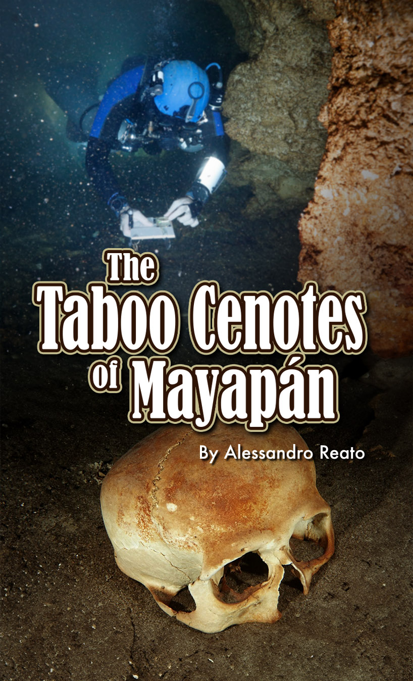
Bil Phillips previously introduced me to Professor Bradley Russell at the end of 2014. Professor Russell’s research in the fortified city of Mayapán had led him to discover multiple human remains submerged in the taboo cenotes of Sac Uayum and San José. Mayapán was one of the most important political capitals of the Maya civilization in its Post-Classic period, between 1150 and 1450 AD. An international group of archaeologists from Mexico and the United States carried out the major parts of this study.
The curiosity regarding the two cenotes, Sac Uayum and San Josè, is that they are located outside the city walls; a strange fact if you consider that for the Maya the cenotes were sacred places: sources of life, the only points where it was possible to stock up on water throughout the year, as well as entrances to Xibalba, the underworld inhabited by the dead.
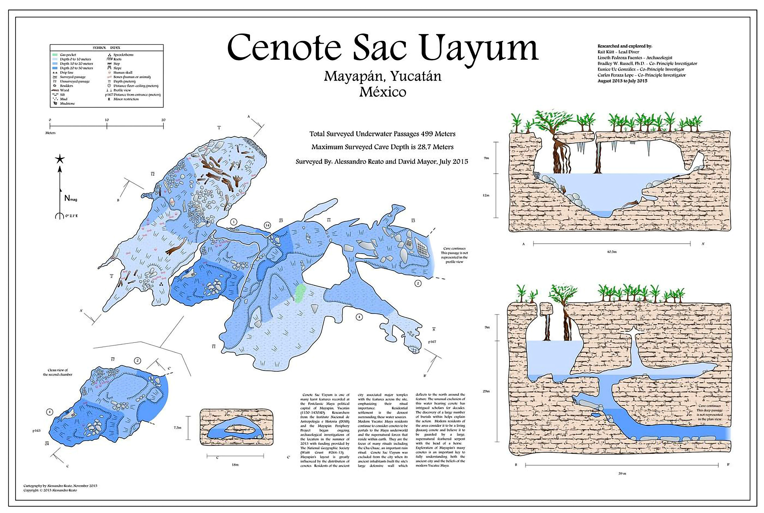
Bradley had the goal of being able to reach the second chamber of the Sac Uayum cenote, where some divers had found perfectly preserved human remains. To access it, it was necessary to pass, at a depth of 10.5m/35ft, through a restriction just under 10m/33ft long, then go down to depth, up to 18m/60ft and then go back up a few metres.
How could these bones have gotten there? Did they belong to people who lived in the Post-Classic period? Or were they prehistoric individuals who died in the caves when they were dry? If this last hypothesis were correct, why would there be so many remains, given that they had counted 14 human skulls?
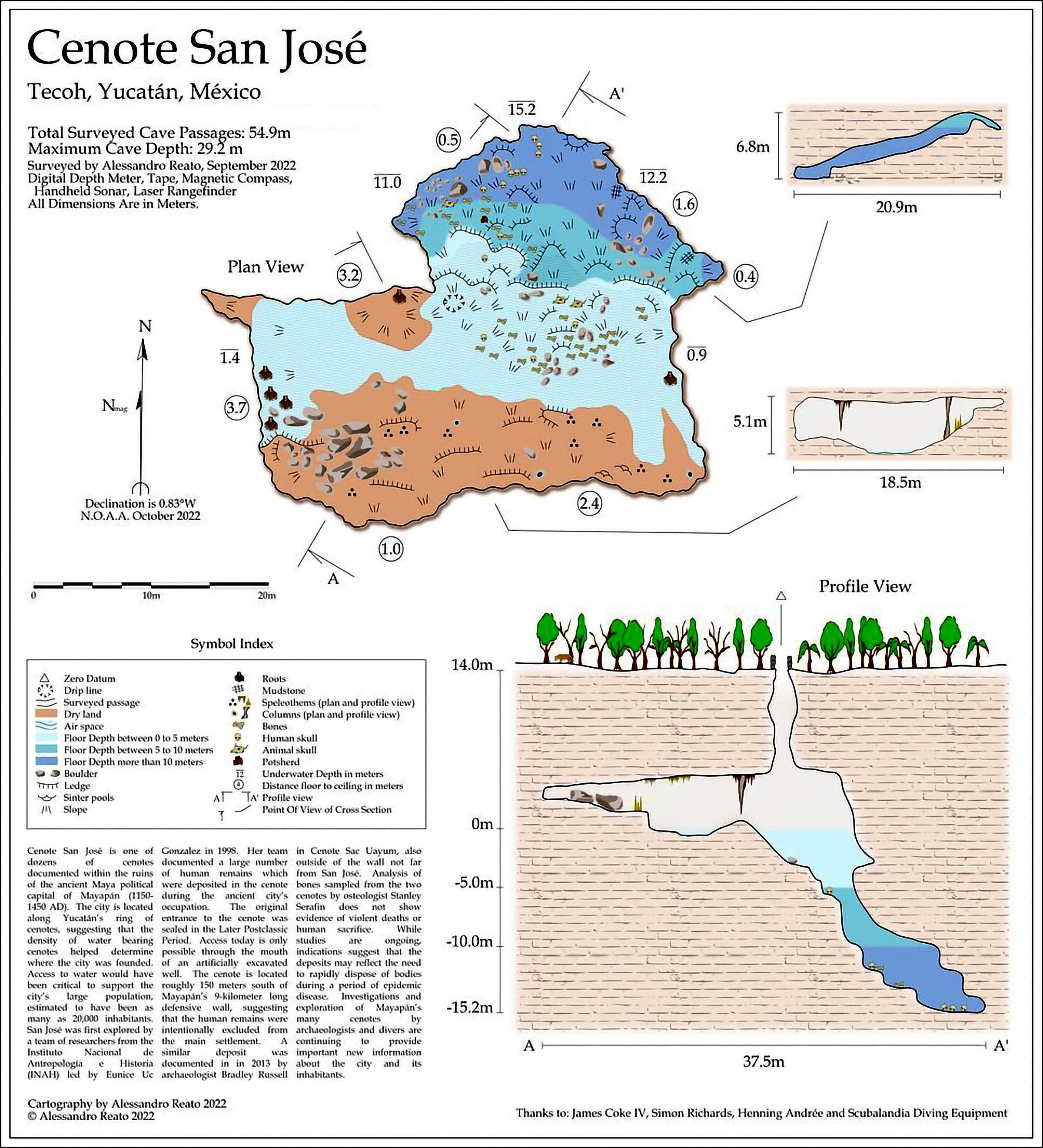
The scenario of the San Josè cenote was very different, where the human remains were even more numerous and covered the bottom from just a few centimeters deep up to the deepest area farthest from the access.
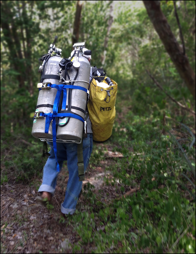
My friend and colleague David Mayor and I first visited the Mayapán in July 2015, where we accepted the task of creating a detailed cartography of the Sac Uayum cenote. Upon our arrival in the village of Telchaquillo, brutal heat immediately greeted us. During the day, it was a formidable task to wash your hands due to the temperature that the water reaches when flowing through the pipes outside. For those who are not used to it, it is difficult to even sleep with these levels of heat and humidity, but luckily they invented beer and the refrigerator.
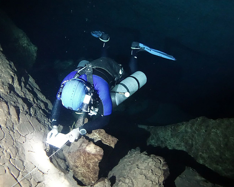
Over the course of a few days of diving we collected a sufficient amount of survey data to represent the cave on the plane, while Bradley, thanks to his successfully completed cave diver training, could finally admire firsthand what until then, he had only seen thanks to a series of photographs.
All this is not without risk: a local legend tells of a monster with a snake's body and a horse's head guarding the cenote, ready to kill and devour anyone who dares to venture inside. Therefore, we had to ask a local shaman to intervene and perform the ritual, convincing the supernatural forces that we were driven by scientific intentions.
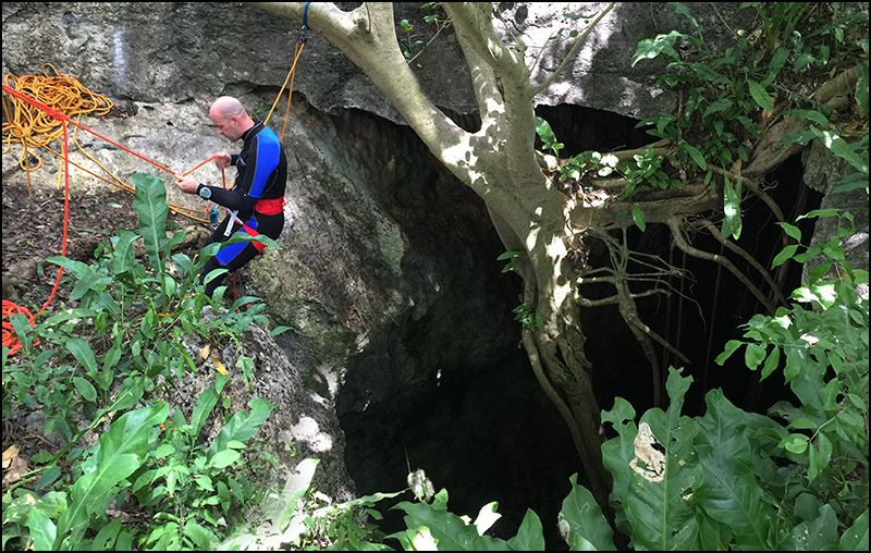
Access to the water is quite complex. The entrance to the cave is a hole in the ground with a diameter of about 4m/13ft, from which you have to descend vertically for about 10m/32ft until you reach the surface. A system of ropes is essential for entering and exit; fortunately there is no shortage of rope anchor points, made up of the trees that grew on the edge of the pit entrance.
Collecting the survey data was an almost surgical operation: a thick layer of organic sediment, dark and very light, completely covered the bottom of the first chamber, exposed to the external environment. Any movement of the fins, made close to the bottom, drastically reduces visibility because of the absence of water flow.
A thick layer of clay, comprising microscopic particles deposited over the millennia, covers the floor of the second chamber and the innermost part of the cave. Here, a poorly executed movement can reduce or eliminate visibility for hours, giving the sensation of being immersed in milk & coffee.
With the data collected, we could reveal the mystery of the human remains in what seemed to be a difficult to reach location of the cave. In reality, the second chamber is located almost directly underneath the first, and it is clear, over the centuries, the increased layers of sediment blocked the fissure crack from which the bones sank.
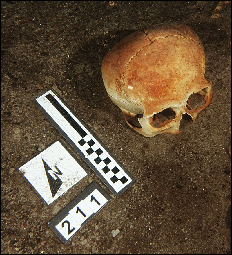
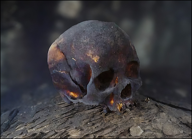
The powerful emotion felt by Bradley was also clear in finally finding himself in front of the best preserved skull in the cave, magically positioned "upright", which belonged to a young woman; after this dive Bradley began referring to this find as "My Girlfriend".
I returned to the Mayapán area in May 2018; when Bradley Russell and his team of researchers had finally received authorization from the Mexican government to extract the skulls found in the Sac Uayum cenote, in order to carry out dating tests and try to shed some light on the mystery that surrounds the two cenotes. Bradley continued with the same team and again asked for David Mayor's and I to take part. While I would have taken care of the removal of the skulls found in the first chamber together with the archaeologist, David would have gone down to the second chamber alone to take all the photographs of "Bradley's girlfriend" to then create the photogrammetry and the 3D model.
In the three years that have passed since our first stay in Telchaquillo, the heat has not diminished and, thanks to our experience, we brought a decent quantity of beer and made sure that the refrigerator was working well.
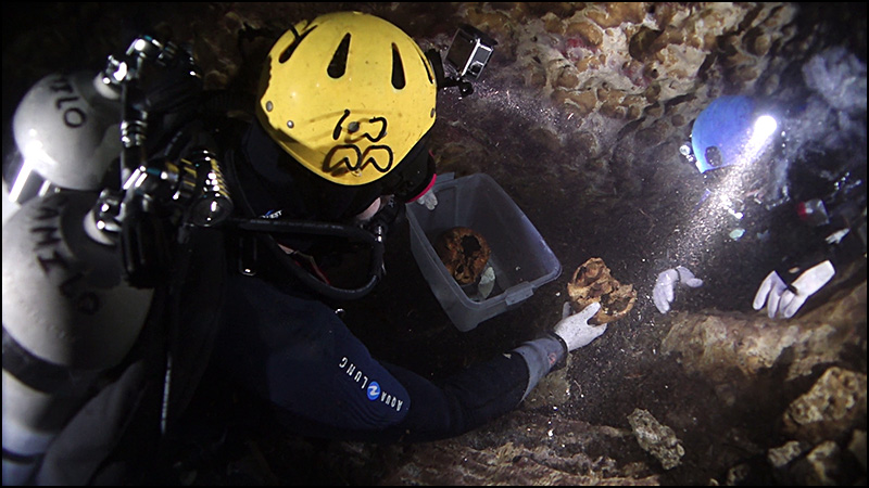
After an accurate course regarding all the things not to do during the extraction of archaeological finds and human remains, we started with the diving. Bradley and I extracted the skulls and package them in appropriate plastic cases containing the same water as the cenote and to transport them to the surface, where other project participants hoisted them through the opening of the cenote.
(Click Maps Below to Enlarge)
Note: GPS coordinates have been removed to help prevent damage to the system and relics.
New discoveries quickly appeared when, by lifting some skulls, we also removed the sediment that partially covered them and revealed others underneath that were no longer hidden from view. In fact, the number of skulls extracted from the cenote almost doubled from the 14 previously inventoried. I remember that Bradley's eyes shone with emotion: one of the most important projects of his career as an archaeologist had reached a crucial point and, honestly; I felt honored to be part of it. The final analyzes confirmed the discoveries to date around 1350 AD.
Bradley and the other researchers deduced the deaths were most likely associated with famine and disease during a drought in the mid-1300s, and that the cenote was used to avoid or limit contagion or, more simply, as a mass burial. The team is currently waiting to secure funding to carry out studies on DNA from dental tartar/plaque deposits and consequently detect disease pathogens.
Another four years had to pass before we could return to Telchaquillo which, in the meantime, remained as warm as it was before. A French production company, linked to the National Geographic Channel, desired to create a documentary on the Post-Classic period of the Mayan civilization and, in the research of experts in the sector, they came across the name of Professor Bradley Russell and his team. Bradley seizes the opportunity and proposes to the producers to include in the documentary the mapping of the San Josè cenote. The producers liked the idea: filming an underwater cartographer while surveying data from a submerged cave, in an environment linked to the principal subject of the documentary. Unfortunately, the National Geographic Channel stated they didn’t have an underwater videography expert in cave diving available. And this is how David Mayor, Bradley Russell and I meet again to fit another piece into the puzzle of Mayapán and its cenotes.
3D Animation Model of Female Skull
The San Josè cenote is characterized by simple dimensions; the entrance is a chimney, 14m/45ft of vertical descent, which gives access to the domed area of the cave. In this dome area, the air has very little oxygen and breathing can be difficult. The flooded section of the cave is a descent partly covered with organic sediment with rocky steps up to a maximum depth of 15m/50ft. The remains are everywhere, both human and animal, so much so that it is difficult to classify them; obviously except for human skulls, of which there are 13 visible.
Here too, the data collection work required obsessive attention, both to avoid moving the bottom as much as possible and to avoid damaging the finds; unfortunately it was not possible to avoid the percolation of dust from the ceiling because of the bubbles.
Although there were no problems with poor visibility, the lack of oxygen in the aerial part of the cave made the data collection work difficult. The characteristics of the entrance do not favor ventilation and for the entire time spent in the cave, I suffered from "air hunger".
On the second day of the survey, the water was still cloudy, as there was not the slightest flow that could carry away the suspended particles.
Drawing the survey data on the slate was not as "simple" as in my other works, as I suffered terribly from the lack of depth visual. Having to travel the same distances back and forth, often several times, only made the already poor visibility worse. In some places, rather than drawing, I limited myself to taking notes; thanks to the three-dimensional reconstruction of the data, I could "extrapolate" the space of the cave. David waited until the work was finished to come in with the camera, in order to avoid further worsening the visibility.
As always, working on the computer required multiple hours than that spent in the cave. Apart from having to redraw all the notes taken underwater, the visual impact and ease of reading the map cannot be missing, things that require examining various representations to decide the one that best conveys the idea. James Coke IV was generous with advice this time, too. Having a critic of his experience makes the work of reviewing infinitely easier.
Thanks to David Mayor, we never had to repeat scenes. Having the result in mind before even picking up the camera is essential to be an excellent diver. Special thanks to Bradley Russell for inviting me onto the research team. More and more often, I think that the exploration and cartographic work I have completed has led me to meet excellent professionals. And, as always, I cannot forget to thank Bil Phillips, who helped me understand what I wanted to do when I grew up. Bil was the cave diver I would like to be.