
|
|
|
 |
(CLICK TO ENLARGE ABOVE IMAGE) |
| |
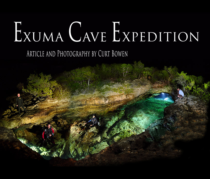
Dr. Thomas Iliffe, the worlds leading cave biologist invited some of the staff of Advanced Diver Magazine to assist with his on going project of searching for new cave life. The Exuma Islands are a hot spot for unique cave adapted animals found no place else on earth.
With limestone layers over a thousand feet thick, it’s no surprise that the Exumas and Bahamian islands are littered with giant blue holes. Blue holes are the Bahamas term for cave, cenote or spring. Many of these blue holes move massive amounts of water in and out between low and high tides in the earths never ending attempt to equalize water pressure. Unlike solution caves, most blue holes are surface entrances into submerged fracture cracks. These cracks where caused by weaken limestone ridges that fractured due to their own weight during past ice ages when ocean levels were up to 300 feet shallower than today. These cracks are normally narrow from side to side but can be extremely tall and deep, many times in excess of 400 feet.
The Caribbean Marine Research Center (CMRC) located on Stocking Island, Exuma would be our base of operations for the 15-day expedition. The typical daily team activities included searching and exploring new cave entrances, collecting specimens, and then analyzing our discoveries during the dusk hours.
Accessing the cave entrances became a challenge in itself. The landscape consists of a dry rough and rocky limestone base covered by thick mangrove, scrub brush and poison wood trees. Poison wood is a species of small shrub that when touched or rubbed up against with bare skin causes a nasty blister rash that can take several months to clear up. |
|
| |
 |
| |
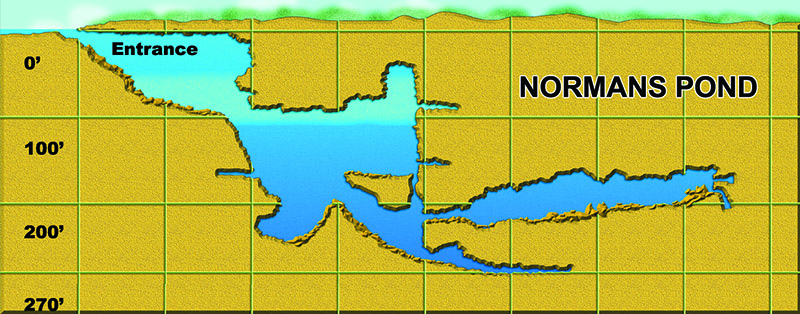
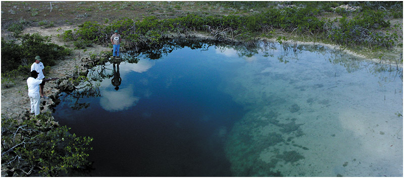
Normans Pond (Map and photo above) is located only a couple miles from CMRC right on the shore of Normans Cay. First explored and mapped by Brian Kakuk, Normans Pond Blue Hole drops straight into a deep fracture crack cave with depths in excess of 270 feet. Water visibility is normally 100 feet plus below depths of 130 feet. The cave system heads inland towards the center of the island.
Examining the topographical map of Normans Cay showed an interesting pond just 0.67 miles from Normans Pond cave and in a straight line its fracture was heading. Obtaining the best GPS numbers as possible from the topo map we headed out to hack our way through the thickets in an attempt to reach the mysterious pond. After an hour of weaving a path through the thick brush we found ourselves standing on the mangrove covered banks of a small salt pond. A quick snorkel dive revealed a small cave entrance on the side facing Normans Pond cave.
Transporting the required sidemount equipment in for a quick reconnaissance and collection dive proved even more difficult. Once the team reached the pond two divers entered the small cave entrance and into a medium sized passage covered with plant debris and heavy silt. Continuing onwards the cave dropped to a depth of 70 feet and then finally into a large room no more than a 400-foot penetration from the entrance.
At the end of this room, a very small no-mount restriction dropped straight down through a slice in the floor. Opting not to squeeze through the restriction the team returned to the surface with their newly discovered news and collected specimens. The team named the new cave system Normans Blue Hole. |
|
| |
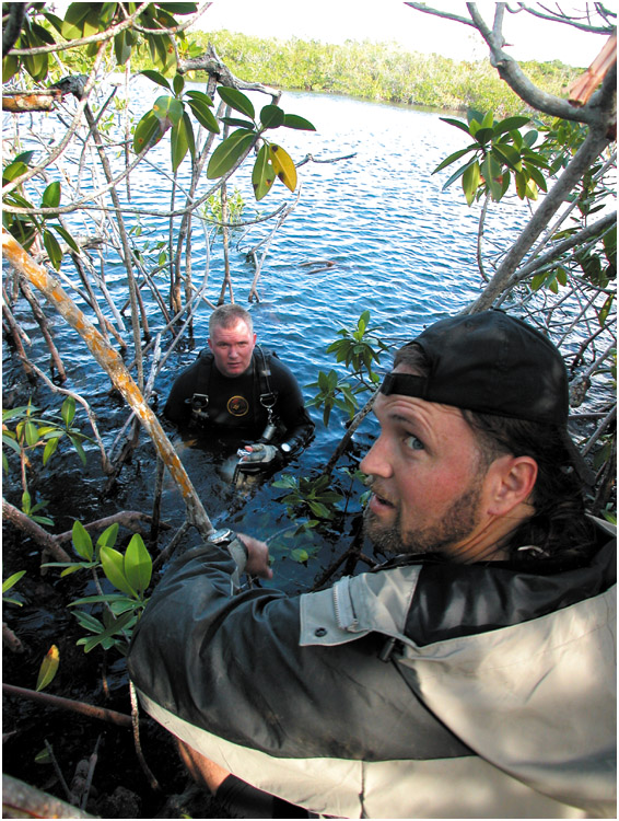 |
Above: Cave explorers, Curt Bowen and Brett Hemphill reach the mysterious pond located through the thick mangrove patches of Normans Cay, Exumas. Watch out for the poison wood!
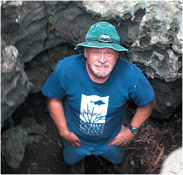
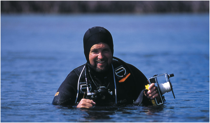
Below: Dr. Iliffe seaches for new dry cave passage through small solution tubes known as banana holes |
|
|
 |
| |
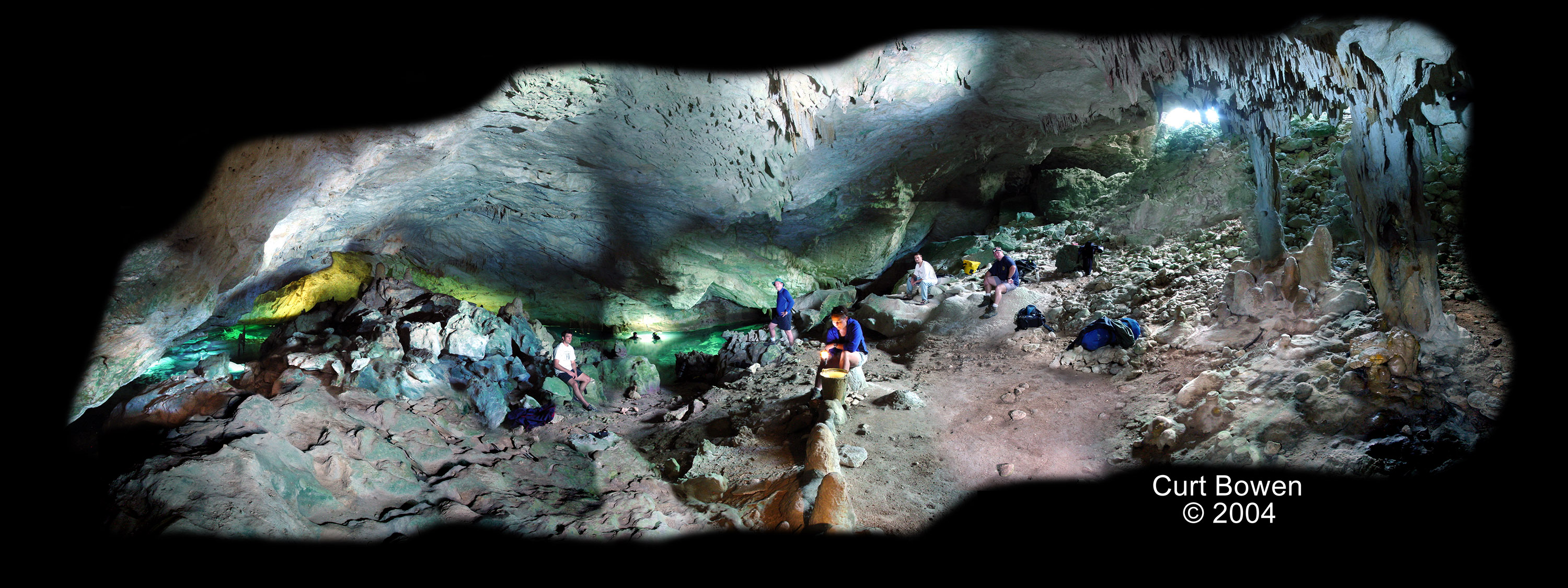
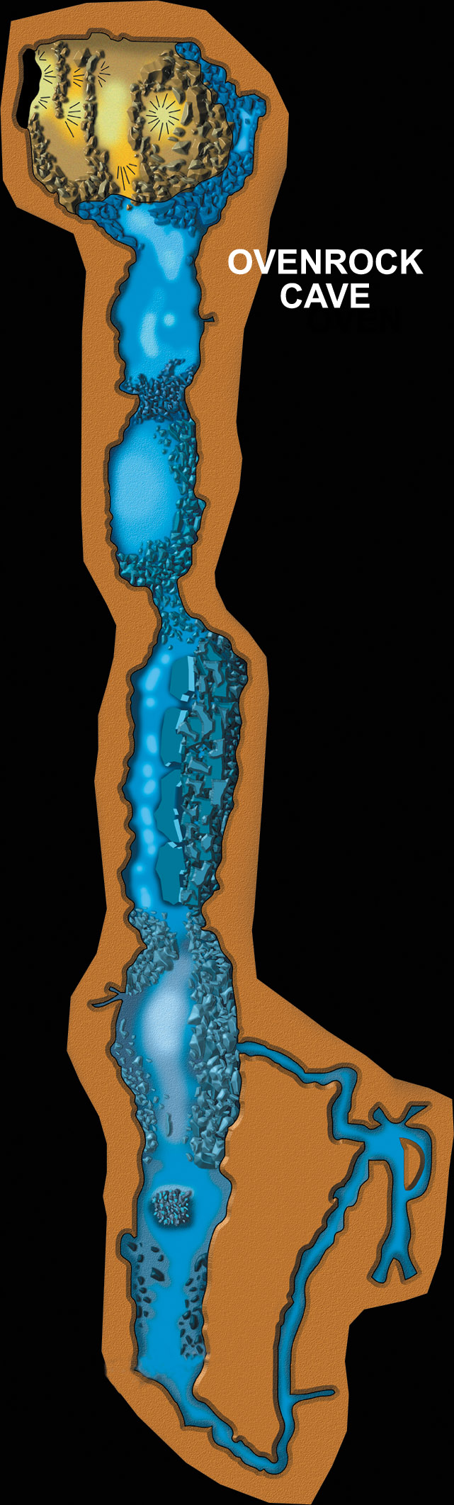
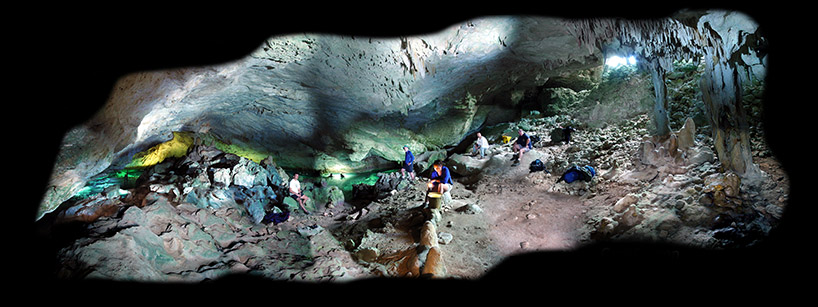
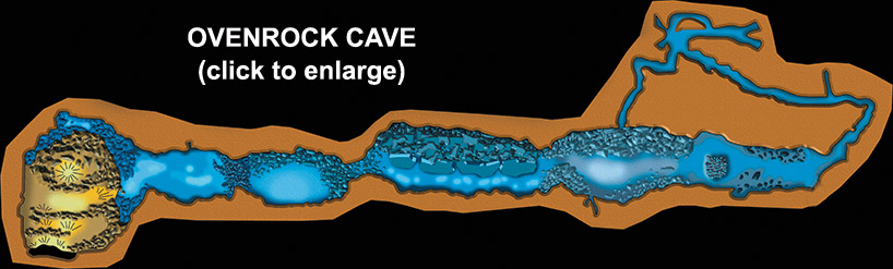
Twenty-five miles north of CMRC lay a large desolate island containing one of the few Exuma solution caves, (created by erosion affects of flowing water). Ovenrock Cave contains the largest dry cavern zone in the Bahamas and is featured below with a multi exposure, time lapse, and light cave painting.
Dr. Iliffe considers Ovenrock a gold mine for isolated cave animals with several new species never before described discovered. Pristine cave formations highlight the first several hundred feet of underwater passages. Large deposits of prehistoric bat bones are scattered throughout in room number two, a sign of life activities when the passages were dry. This specific cave is protected and off limits to diving without the proper scientific permits.
Continued exploration on the large island of Grand Exuma revealed large inland mangrove swamp zones by the small village of Mosstown. These swamp zones are surrounded by tall hills cutting off their direct contact with the surrounding sea. The tides in these swamp zones rise and fall dramatically with the changing of the tides indicating they must be connected to the ocean by underground rivers.
Dr. Iliffe and Brian Kakuk in a past expedition had discovered a large blue hole along the shore of the mangrove swamp called Mosstown blue hole. Brian has conducted a couple exploratory dives into this blue hole discovering a steep slopping passage dropping through layered limestone and into a large river tunnel at a depth of 220 feet. Due to the swift water currents during the tidal changes, continued exploration of Mosstown blue hole would require precise dive planning.
A trick to exploration in unfamiliar countries is to ask the local residence. Find the oldest fisherman or farmer possible that has lived in the area their whole life, they know every inch of ground within 30 miles of their property. A small donation will save your team hours of bush beating. |
|
| |
 |
(CLICK TO ENLARGE ABOVE IMAGE) |
| |
 |
| |
To our luck, just such an elderly gentleman was sitting on his porch in the center of Mosstown. After a few minutes of conversation, we actually convinced him to jump into the truck and show us two new holes within a couple of miles from his porch.
Blue hole one (photo below) was located down a small dirt road just on the edge of a mangrove swamp. The locals called this blue hole Crystal, for its cobalt blue watercolor. A quick recon dive into the system revealed a tight, sidemount breakdown that skirted along the cave ceiling and pinched off at a maximum depth of 102 feet. No passable passage was discovered unless you desired to attempt a no-mount push.
Blue hole two actually turned into blue holes two and three located in the main water channel in the mangrove swamp, just a stone’s throw from the bank. The team discovered and named the new discovery Mosstown Twins. Two separate holes lay within 60 feet of each other and both were pumping large amounts of water into the swamp at the time the team explored them. Explorer Brett Hemphill conducted the first exploratory dive in both holes. Hole one, located in the center on the channel, dropped at a 45- degree angle until it hit a flat 14-inch tall by 25-foot wide bedding plain at a depth of 222 feet.
Returning to the surface, Brett had enough line left on his exploration reel to drop into the second hole located against the far bank of mangroves. The passage continued down like hole number one, but with larger tunnel and increased water flow. Brett’s line ran out in large dropping tunnel at a depth of 70 feet, requiring him to end the dive. Of course, luck has it, this was our last day on the expedition, leaving Mosstown Twins blue holes for other future eager explorers. |
|
| |
 |
Above: A local elderly gentleman shows the team Crystal Blue Hole entrance, located within a few miles of Mosstown, Grand Exuma
Below: Explorer Brett Hempill gloats about his almost empty reel as he returned to the surface from the first exploration dive into Mosstown Twins blue hole |
|
|
 |
|
| |
|